Published: October 31, 2022
IN THIS ISSUE
- Video Summary
- Look Back at Last Season
- Climate Outlook NDJ
- Look at Next Season
- Announcements
Published: October 31, 2022
With La Niña unfolding in the Pacific, only few areas received less than the usual amount of rainfall. Most areas recorded at least seasonably high — or even higher — rainfall totals for this portion of the wet season. Fewer heatwaves occurred than in recent hot years (such as 2020), but high humidity led to a peak in heat stress in September.

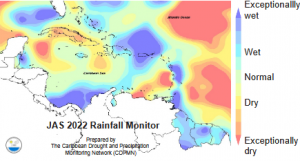
RAINFALL: Parts of Cuba, St. Vincent very dry; Barbados Central Bahamas, Dominica, Dom. Rep., Guadeloupe, much of Guyana, Saint Lucia, Suriname and Trinidad & Tobago very wet… More Information

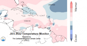
TEMPERATURE: Near average temperatures in much of the Caribbean, but Antigua, parts of Barbados, northern Belize, Curaçao and Trinidad were significantly cooler than usual… More Information

GLOBAL: …
WET: 1 location in Dominica, 1 in Guyana, 1 in Martinique, 1 in Tobago recorded their highest rainfall totals for this period (~150-180% of avg.).
HOT: 1 location in Dominica recorded its highest daytime maximum temperature for this period.
This transition between wet and dry season is forecast to feature frequent wet days, excessive rainfall in the ABC Islands, Belize and the Lesser Antilles until December and the coastal Guianas through January. This results in frequent disruptions of outdoor activities and rising water levels in soils, rivers and reservoirs.
The potential for floods and cascading hazards is high to extremely high in the ABC Islands, Cayman Islands, coastal Guyana, Dominican Republic, Lesser Antilles, western Jamaica and Suriname, and moderate to high in most other areas. Strong tropical cyclone activity may still develop until the end of the year, particularly over the Caribbean Sea. Temperatures return to being comfortable.
Belize: Nov to Dec – wet season. Frequent heavy showers. January – dry season. Few heavy showers in some years.
Caribbean Islands north of 16ºN: Nov to Dec – transition to dry season. Decreasing shower frequency & intensity. January – sunny days and some days with showers.
Caribbean Islands south of 16ºN (incl. ABC Islands): Nov – wet season. Frequent heavy showers. Dec to Jan – transition to dry season. Decreasing shower frequency & intensity.
Guianas: Nov to Jan – wet season. Frequent,
heavy showers… More Information
Above normal rainfall expected for the ABC Islands, Windward and Leeward Islands, and the Guianas, and to a lesser extent, in Hispanola and Puerto Rico. Dryer than normal conditions expected for Cuba and Belize, as well as the Bahamas, Turks and Caicos, and the Cayman Islands. Jamaica is expected to have equal chances of near-normal, above normal, and below normal rainfall… More information

Flash flood, long-term flooding, land slide, rock fall and widespread soil erosion potential remain a concern across Belize, the Islands and, from late-November, the coastal Guianas due to very wet spells and extreme wet spells.
Decreasing surface wetness makes environmental conditions progressively less conducive to mosquitoes & moisture related pests in Belize and the islands… More Information
NDJ night-time (min.) and daytime (max.) temperatures are forecast to be close to the
usual or slightly lower in many areas, except for Guyana and, at night, in Antilles south of Guadeloupe.
Heat stress should rapidly decrease in the Guianas and, in the remainder of the region, no longer be a regular concern as the region transitions to the cool season… More Information

Latest drought situation (as of October 1st, 2022): Severe (or worse) short-term drought has developed in parts of Cuba and in St. Vincent; severe (or worse) long-term drought has developed in Antigua, Western Cuba, southwest Haiti, eastern Jamaica, Martinique, St. Barts, and St. Vincent.
Shorter term drought (at the end of Jan. 2023): There is no concern for short term drought for the region at the end of January 2023.
Long term drought (at the end of Nov. 2022): Long term drought might possibly develop or continue in western Belize, Sint Maarten / St-Martin, St. Vincent, and the USVI… More Information
For sector specific interpretation, see the latest issue of the Drought Bulletin
Indications are that the peak of the 2022-23 dry season may be characteristic of a La Niña event. Wetter than usual conditions are likely in the Guianas, the ABC Is. and the Lesser Antilles. However, it may possibly be even drier than usual in the Bahamas and the Greater Antilles westwards of Haiti.
Frequent dry spells may impact crop production, particularly in the northwest of the region. Temperatures usually remain comfortable through March as the Caribbean cool season draws to an end, but tend to increase in April. It should be noted that Saharan dust incursions into the region may increase during this period… More Information

Recent observations: Sea Surface Temperatures (SSTs) in the eastern Pacific remain below normal (i.e. -1°C); La Niña conditions have so far maintained for all of 2022.
Model forecast and guidance: The forecast models indicate La Niña conditions in NDJ (95% confidence), possibly reverting to neutral conditions by FMA (55-60% confidence).
Expected impacts on rainfall and temperatures: La Niña tilts the odds to more rainfall NDJ and FMA, except in the northern Caribbean where it tilts the odds to less rainfall. ENSO neutral offers little contribution to seasonal rainfall or temperature prediction in the Caribbean… More information

Recent observations: SSTs have risen to 0.5-1°C above average in much of the Caribbean Sea and the Tropical North Atlantic (TNA), and remain at that level in the sub-tropical North Atlantic.
Expected conditions: Models are forecasting observed SST to return to between 0°C and 0.5°C above average across the Caribbean Sea and the TNA.
Expected impacts: Warm SSTs in and around the Caribbean tends to contribute to higher air temperatures with above-average humidity, but also higher Atlantic Hurricane Season activity, seasonal rainfall totals in an increased frequency of extreme rainfall except in the north.
The Dry Season CariCOF will be held in Bridgetown, Barbados at the Accra Hotel on November 22-26, 2022. The four day event will bring meteorologists, stakeholders from the agriculture, tourism, and health sectors together to hear the climate outlook for the coming season and the implications for their sectors. The meeting will be held in a hybrid format. Please contact us for an invitation.
We have been testing a new format for the CariCOF Caribbean Climate Outlook Newsletter in order to modernize our products, improve our workflow, and increase engagement with users. Please share your thoughts on the newsletter by sending an email to caricof@cimh.edu.bb
DISCLAIMER: The information contained herein is provided with the understanding that CariCOF makes no warranties, either expressed or implied, concerning the accuracy, completeness, reliability, or suitability of the Outlook. The information may be used freely by the public with appropriate acknowledgement of its source, but shall not be modified in content and then presented as original material.
Caribbean Regional Climate Center
Tel : +1 (246) 425 1362/3
Fax: +1 (246) 424 4733
Email: caricof@cimh.edu.bb
The CariCOF Caribbean Climate Outlook Newsletter is a summary of recent and expected seasonal climate events and their headline impacts throughout the Caribbean. It provides consensus rainfall, temperature and drought outlooks for the coming three to six months in map and textual formats. Also included is an explanation of the outlooks in context of ongoing global and regional climate conditions. Read more
For weather and climate information specific to your country, please see your national meteorological service.

Click here to add your own text

Click here to add your own text
Caribbean Institute for Meteorology and Hydrology
Husbands
St. James
Barbados BB23006
CONTACT US
P.O. Box 130
Bridgetown
Barbados
Tel : +1 (246) 425 1362/3
Fax: +1 (246) 424 4733
Email: rcc@cimh.edu.bb
